Attractions > Linville Falls Information

Linville Falls Recreation Area

fun for the whole family

linville falls waterfall photography

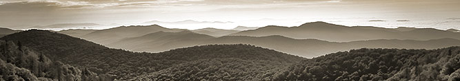
The Linville Gorge is formed by the Linville River which runs between Linville Mountain on the west and Jonas Ridge on the east. The terrain is extremely rugged with elevations ranging between 1300 feet and 4120 feet. The forest is dense with Oak, Hardwood, Pine, Hickory, Birch, Sweetgum, Rhododendrons and other varieties of trees and plants. Linville Falls, NC was a popular resort destination long before the Blue Ridge Parkway was built. Fabulous waterfalls, clear waters, stands of virgin timber and the deep rugged gorge are all reasons why this area is such an amazing place to visit.

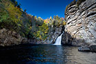
Linville Falls is an amazing waterfall 150 feet in height with the highest volume of water flow than any other falls on the northern edge of the Blue Ridge Mountains. It starts with a twin set of upper falls and spirals through a small canyon where it then plunges 45 feet to the Linville River below.

The Linville Gorge Wilderness Area, sometimes referred to as the "Grand Canyon of the East" is located in Western North Carolina in the Pisgah National Forest. Even though there were many eastern forests that were being logged around the turn of the century the Linville Gorge Wilderness Area was spared because the terrain here is so rugged . One of the few remaining old growth forests this area has some of the best remnant stands of uncut forest in the southern Appalachians.

Linville Gorge is one of the deepest scenic gorges in the eastern United States.

Many hikers, campers and rock climbers visit the Linville Gorge Wilderness area every year. The trail system spans 39 miles and is well maintained by the Grandfather Ranger District of the United States Forest Service and offers hiking that is strenuous and challenging for those who enjoy hiking.

Linville Falls Visitor Center offers maps of the area and hiking trails. It's open from April 15th to November 1st.

History

The Linville Gorge Wilderness became a designated wilderness area in 1951. It was originally 7,575 acres and has increased to 10,975 acres. The Cherokee name for Linville River was Eeseeoh which means "a river of many cliffs". Linville Gorge was named in honor of Explorer William Linville and his son John Linville who were massacred by Cherokee Indians there in 1766.

Things To Do

The Linville Falls trail system is designed to take you to different overlooks for viewing the upper and lower falls. There are several trail options including 3 spur trails: one leading to views of the Upper Falls, one leading to the Chimney View and Erwin's View, and one leading to the Plunge Basin Overlook, all of which offer different perspectives of the cascades that tumble into the Linville Gorge. The skill level ranges from easy to strenuous. Hikers should also be wary of snakes including copperheads and timber rattlesnakes.

Hunting and fishing are allowed but permits are required.

Camping is permitted in the gorge but permits are required from May 1 through October 31. The Linville Falls campground area is on the Linville River with access to the trail system into the Linville Gorge Wilderness Area.

There are 3 great trails located in the Linville Gorge area for mountain biking: Linville Gorge Loop and Table Rock Loop are difficult and strenuous, but the Wiseman's View Ride is considered to be moderate.

The trout stocked waters of Linville River make an excellent place for fishing for Brown Trout, Rainbow Trout and Brook Trout.

Rock climbing is permitted in all areas of the park.

Swimming is prohibited as it is very dangerous.

Location

The Linville Gorge Wilderness area is part of the Pisgah National Forest in the Mountains of Western North Carolina. The road to Linville Falls is located at milepost 316.5. You'll pass by Linville Falls Campground on your way to the large parking area at the visitor center and trailhead.

Share This Page

Add to: Facebook Add to Twitter Del.icio.us Stumbleupon Digg reddit